The photo was taken by Linda Nelson on May 20, 2017, with her Alcatel a30 cellphone.
Edward MacDowell Lake in Peterborough, Nh
Last month my integrated science class assignment to write a paper on a Natural Resource. I chose a resource in my local so I could visit the place first hand to complete my research which was written in MLA style.
I have yet to discover which writing style is more welcome in the blogging community. Between MLA, APA, and CMS, I prefer MLA. If anyone can correct me on the proper blogging style, please do.
Please enjoy.
Introduction
There is a man-made lake in Hillsborough County that is the focus of this research. The lake is Edward MacDowell Lake in Peterborough, NH. Built for flood control in the Monadnock area. Flood control began back in 1907 when a flood overtook Pittsburgh, Pennsylvania killing residents and destroying buildings and property bringing about the first Flood Control Act of 1917. Approximately 40 more years would pass before the Edward MacDowell Dam would be built.
Details follow about the Physical Geography and the natural resources found in Hillsborough County. The founders of the MacDowell Colony are a central focal behind the cultural aspect of the lake for inspiration and experiencing nature enhancing the need for the natural environment of Edward MacDowell Lake. The technology surrounding the usage of the dam allows for those in charge of water flow to make the appropriate decisions when to release water and when to shut the dam gates. Concluding the research is what happened in American society that made Congress act.
Physical Geography & Natural Resources
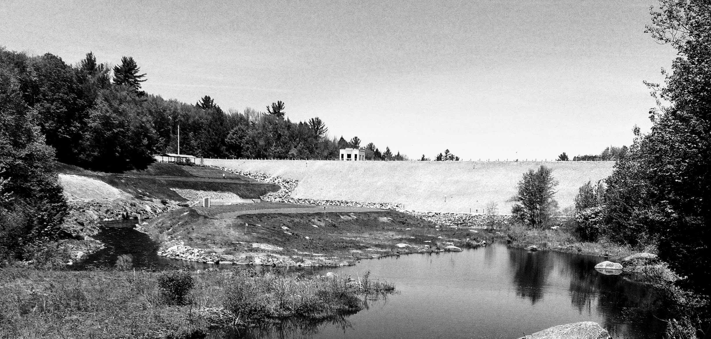
Edward MacDowell Lake in Peterborough, New Hampshire was formed by building a dam by the US Army Corps of Engineers in March of 1948 for flood control for not only Peterborough but also several other towns such as Hancock, Bennington, Antrim, Deering, Hillsboro, and Henniker which all reside on the Contoocook River. (Engineers)
14 miles east of Keene, New Hampshire on the Nubanusit Brook in Peterborough is where the dam was built to create the lake. Edward MacDowell Lake is an earthfill dam. It has a stone slope of 1,100 feet long, and it is 67 feet high with a gated concrete conduit that is approximately seven feet wide and seven feet high and 275 feet long. The chute spillway that is cut in rock is not adjacent to the dam which is an unusual feature. Instead, the spillway for the lake is located 3.2 miles northeast at Halfmoon Pond. The spillway flows from the pond into Ferguson Brook and then into the Contoocook River. (Engineers)
The lake is 165 acres with a maximum depth of approximately seven feet. But yet, parts of Hancock, Dublin, and Harrisville are included in the 840 acres of flood storage area which can store about 4.2 billion gallons of water which include 1,469 acres of land. (Engineers)
The soil makeup of the Monadnock region where MacDowell Lake resides consists of well-drained soils that derive from granite and gneiss which are on side slopes of hills and ridges. These slopes range from 3 to 35 percent. The soil tends to be stony fine sandy loam in the Peterborough, New Hampshire area depending upon the grade of the slope. 0 – 4 grade is found to be very bouldering fine sandy loam. 4 – 28 grade, which is the majority make up of the Peterborough, the area consists of fine sand loam that is cobbly. A 28 – 60 grade slope consists of gravelly loamy fine sand. The minerals found in this area is made mostly of granite. The soil in this region is suited to drought-tolerant conifers and hardwoods of red oaks and white pine. Adding manure and mixing crop residue such as compost will help to conserve moisture and maintain the soil tilth. Most crops consist of pasture or hay. The large stones lower the desirability of farmland and main crops. (Handler)
Edward MacDowell Lake is a Federal Park land and is part of the Merrimack River basin. The park offers hiking, picnicking, fishing, equestrian trails, biking, and boating. Other State Parks in the Monadnock region are Annett Wayside Park, Greenfield State Park, Miller State Park, Monadnock State Park, Pisgah State Park, and Rhododendron State Park. (Parks)
Cultural Aspects
Edward MacDowell Lake is one of the few Federal parks in the state of New Hampshire. Other Federal Parks in New Hampshire are Franklin Falls Dam and Blackwater Dam both of which are in Franklin, New Hampshire. Elm Brook Park in Contoocook. Otter Brook Lake and Surry Mountain Lake both in Keene, New Hampshire. (Parks)
In 1907 the MacDowell Colony settled in Peterborough founded by the wife of Edward MacDowell, Marian before his death in 1908. This artist community was a dream of the composer built on their farm property in Peterborough. Soon the colony became nationally known as the “Peterborough Idea.” The idea drew figures such as Grover Cleveland, Andrew Carnegie, and J. Pierpont Morgan who then created a fund in Edward’s name to make his dream a reality. (About MacDowell)
More than a decade before the MacDowell Dam was built floods devastated the area bringing about the need to create a form of flood control to protect the surrounding area. Construction of the dam began June 1936 following several devastating floods in New England that Spring. An abnormally high snowpack created by uncommonly freezing temperatures was the primary source of the flooding that year. Then on March 9, a front brought heavy rains of up to 5 inches in parts of New Hampshire and Maine for the next five days. Two more storms drenched the region over the next two weeks. Heavy rain and melting snow caused ice jams on the rivers affecting the entire area of the Connecticut River. Between 150 to 200 people killed by the floods. A hurricane soon followed creating more devastation making the Corp of Army Engineers act. (Farrar)
Originally the lake was named the “West Peterborough Reservoir,” but a name change took place in 1949. The name, Edward MacDowell Lake, honors the late composer who brought about the idea of the Edward MacDowell Colony that formed on his farm in Peterborough, New Hampshire many years earlier. (Farrar)
Incorporated in 1760, Peterborough was charted in 1737 by the Massachusetts legislature. The first settlers arrived in 1739. The first year the census was taken was in 1790 with a population of 861 residents. Today there is a population of about 6,387 people. Which would be about 168.0 people per square of land area. Peterborough has about 38 square miles of land area and 0.4 miles of inland water area. (Security)
The Natural Environment
Floods brought about by abnormally high snowfall and rainfall that impact the Contoocook River avoided flood damages of about $20.8 million since the construction of the Edward MacDowell Dam protecting the natural environment in the surrounding area along with multiple communities, businesses, and agriculture. (Engineers, 2016)
The Natural Environment of Peterborough’s Edward MacDowell Lake is made up of forests of conifers, oaks, birch, and maples. Farming did take place in the past but is not as abundant in the present time most likely due to the poor fertility nature of the soil that consists mostly of clay, sand, and large rock formations. (Handler, 1985)
In fact, Edward MacDowell and his wife, Marian, used their farmland to be the host site of the MacDowell Colony. This establishment created for inspiration in the local artists who would reside on the property. Many famous artists have visited the region over the years. Edward MacDowell Colony is a haven for artists. (About MacDowell, 2014)
When the lake and dam were created the most important feature at the time was to save the residents from devastating floods from ice jams and unusually high rainfall. Today the natural setting of beauty and nature inspires artists of all types, such as painters, writers, musicians, and photographers. Edward MacDowell Lake provides not only recreation but also the wonder of nature to inspire creation in today’s artists. This lake not only provides a means of flood control but it also is a great place to hike, fish, picnic, or swim. (Engineers, 2016)
The Technology
Edward MacDowell Lake is the site of the Edward MacDowell Dam in Peterborough, New Hampshire. The dam was built by the U.S. Army Corps of Engineers to alleviate damage from flooding waters along the Contoocook River. The dam has three flood gates that are used to control the flow of water when the Contoocook and Merrimack Rivers are high.
The Hydrologists and engineers make flood control decisions in the Reservoir Control Center in Concord, Massachusetts. They use satellite technology to form decisions regarding the water control for New England by using a highly sophisticated “Automated Data Collection System” that will relay the level of water in the lakes, rivers and weather conditions of New England to a RCC computer system. The data then is collected by the Geostationary Operational Environmental Satellite. (Engineers)
The first GOES satellite was launched in 1966 as part of an experiment to gather images of the Earth. Altogether, six satellites were initiated as part of the research which was successful. Then the Synchronous Meteorological Satellite was launched in 1974 and became the first operational satellite able to detect meteorological conditions from one location. After the experiments proved to be successful the first satellite that is part of the GOES program was launched from Cape Canaveral, FL in 1975 and was renamed GOES-I when it reached orbit. (Dunbar)
Several more satellites launched over the years. GOES 4-7 brought about Visible Infrared Spin Scan Radiometer (VISSR) and Atmospheric Sounder (VAS) that enabled the measurement of temperatures and moistures. These satellites provided data on the altitudes and temperatures of clouds which allowed more accurate weather predictions. Over the years, the satellites kept improving. Today they can observe and predict local weather events such as thunderstorms, tornadoes, fog, hurricanes, flash floods and other severe weather. They have even proven helpful with monitoring volcanic eruptions, forest fires, and even dust storms. (Dunbar)
The information obtained from the GOES satellites have allowed the RCC to determine the best flood control action that needs to take place by the project staff in regards to opening and closing the three Edward MacDowell Dam flood control gates. (Engineers)
American Society
The Edward MacDowell Dam would not be built in time to prevent several historical buildings from burning because a flood prevented the fire department from responding in time. (Farrar)
Problems with the watershed of the Mississippi, Ohio, and Tennessee Rivers began the political action to create flood control. A flood in 1907 of Pittsburgh that devastated the steel mill city combined with another flood of Ohio in 1913 started the political pressure by representatives to form a House Committee on Flood Control in 1916 and then passed the Flood Control Act the very next year. The congressional act is a major landmark in political history because Congress allocated funding for flood control for the first time. (Billington, Jackson and Melosi)
The Corps were to provide long-term planning that involved local cost sharing. Whenever flood control studies were presented, they were to include comprehensive assessments of the watershed or watersheds. (Billington, Jackson and Melosi)
When the Mississippi Flood that Herbert Hoover called the, “greatest disaster in peace times in our history,” killed between 250 to 500 people and flooded over sixteen million acres destroying buildings, homes and displacing people proved that the “levees only” policy was an enormous error. (Billington, Jackson and Melosi)
After flooding took place in the 1930s in the Peterborough, New Hampshire region money was allocated in 1936 through the Flood Control Act of 1936. The flood affected nearly the entire length of the Connecticut River. Edward MacDowell Dam was built after about ten years of planning for the 1,000-foot structure. (Farrar)
Conclusion
Flooding is always a major concern for communities. People lose property, homes, and lives from floods. Over the years, the creation of the Edward MacDowell Lake provided government and scientific official the ability to prevent or control flooding within the Monadnock area. This lake not only offered flood prevention it has become a wonderful natural setting for everyone’s enjoyment as a Federal Park.
Billington, David P., Donald C Jackson and Martin V. Melosi. The History of Large Federal Dams: Planning, Design, and Construction in the Era of Big Dams. Denver: U.S. Department of the Interior Bureau of Reclamation, 2005. Pdf. 7 May 2017. https://www.nps.gov
Dunbar, Brian. GOES Overview and History. 8 October 2015. 30 April 2017. https://www.nasa.gov
Engineers, US Army Corps of. “Edward MacDowell Lake Flood Risk Management Project.” New England District (2016). Web. 1 April 2017. http://www.nae.usace.army.mil


You must be logged in to post a comment.